
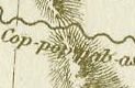
 With the rapidly-rising Boise River in the news every day, Special Collections has created a website featuring digitized versions of eight early maps, 1802-1879, portraying the river as 19th century explorers and mapmakers saw it.
Credit goes to Lewis and Clark for bringing the Boise River to the attention of the outside world. Although he never saw the river, William Clark incorporated it into the map of western North America published with the first printed edition of the expedition’s journals in 1814. Clark derived his knowledge of the Boise River (and of the Snake River system south of the Clearwater) from the Nez Perce Indians. They drew several maps for the expedition depicting the country that Lewis and Clark did not see.
The best and most accurate map was drawn for them on May 29, 1806, by a Nez Perce named Hohastillpilp (Hohots Ilppilp). That map and seven others portraying the Boise River region are portrayed on the website.
Also newly mounted on the Internet is a description of the Boise River valley written by the explorer John C. Frémont in 1843. It is located at http://library.boisestate.edu/Special/Fremont.htm
Alan Virta, Head Librarian, Special Collections
No comments:
Post a Comment